A Decade Trend of Thunderstorm Days at Yangon International Airports (Analysis base on Half-Hourly Observation Data From 2009 to 2019)
Received: 21-Nov-2021 / Accepted Date: 04-Dec-2021 / Published Date: 11-Dec-2021
Abstract
Thunderstorms have a substantial impact on airport performance and, if the airport capacity is limited, can cause operations to be delayed. This study is a statistical analysis of data collected by meteorological stations at Myanmar's YANGON international airports (VYYY) during Thunderstorm days. It spans eleven years, from January 2009 to December 2019. From 2009 to 2019, we have 119874 thirty-minute (xx20, and xx50) Aviation Routine Weather Reports from YANGON International Airport. (METARs).We found 20219 instances of weather phenomena, including 1237 Thunderstorm occurrences, within these records. During Thunderstorms (TS) or Thunderstorm Rain (TSRA), visibility will average 3500 meters with 6.67 percent frequency from 2009 to 2019. Most TSRA occurrences at Yangon international airport may occur between 15:00 and 16:30 in the afternoons on particular TSRA days. 00:00 UTC to 04:00 UTC is the time zone for aircraft. The worst weather phenomena at VYYY are raining during airplane approach due to poor visibility and a strong gust wind. However, the majority of them are caused by thunderstorms. As a result, we may assume that poor visibility, a low ceiling, and thunderstorms and fog are the worst weather conditions for Yangon International Airport. Visibility, cloud ceiling, and thunderstorm or fog conditions are also critical for airport and airplane operations. The highest frequency of thunderstorms happened in July, and the lowest frequency occurred in January. CAPE and K-Index, over the airport region, also increasing year by year. TSRA or convective activities occurrences over airport region are positive correlation with the BoB SST and negative correlation with the Nino region SST over Pacific. After tested the correlation between BoB SST, convective rainfall over airport region, and CAPE Index, we found both CAPE index and convective rainfall over airport region are highly correlated with BoB SST. Thus, BoB SST is the one dominant factor for TSRA occurrence increasing at Yangon International Airport region and further factors may need to study. As noted by a well-known physicist in another context, the current finding poses a new question, as well as a fresh opportunity to look at climatology from a different perspective, and to make significant progress in the predictability study
Keywords: Airport performance; Weather impact; METAR; Thunderstorm; BoB SST
Introduction
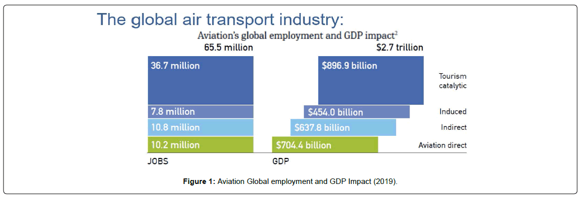
The aviation sector is a vital part of the economies of developed countries like China. Aviation provides the only fast global transportation network, making it critical for international trade. It generates economic growth, creates jobs, and facilitates international trade and tourism [1]. According to the Worldwide Aviation Industry High-Level Group's Aviation Benefits Report 2019, the global aviation industry's total economic effect (direct, indirect, induced, and tourism-related) reached USD 2.7 trillion in 2019, accounting for 3.6 percent of global GDP. In addition, the airline industry supported a total of 65.5 million employments worldwide. It directly employed 10.2 million people. Around 3.5 million individuals were directly employed by airlines, air navigation service providers, and airports (Figure 1). There were 1.2 million people employed in the civil aerospace sector (which manufactures airplanes, systems, and engines). Another 5.6 million people were employed in on-airport jobs. 55.3 million Indirect, induced, and tourism-related jobs were supported by aviation.
Weather conditions such as thunderstorms, heavy rain, wind, fog, turbulence, severe temperatures and pressures, and others can have a significant impact on aviation operations [2]. Commercial aviation is subjected to inclement weather regularly, which has a substantial impact on airline cost planning and service delivery. Considering the above mentioned, airline companies are dependent on the weather forecast to maintain the safety and efficiency of their aircraft and the service it provides [3]. It's all about the money. We've entered a new era in which the weather is currency. Each year, severe weather causes millions of dollars in damage owing to disruption and delays. The key to minimizing the impact on aircraft operations is preparation, and one big impact is the weather [4]. As a result, the best way to analyze the design of each aerodrome to their support operations is to focus solely on historical weather occurrences and their operational implications.
Many weather events will have an impact on aircraft and, as a result, airport operations. Thunderstorms (TS) and fog are the two main meteorological phenomena that have a considerable impact on the aviation business in Yangon (FG). WMO defined that “A THUNDERSTORM DAY IS DEFINED AS AN OBSERVATIONAL DAY DURING WHICH THUNDER HEARD AT THE STATION” since 1971 [5]. Thunderstorms occur from cumulonimbus clouds. These are clouds with a vertical extent extending from 1000 m (330ft) to 12000 m (39000 ft) to the top (Thunderstorm | Definition, Types, Structure, & Facts | Britannica, n.d.) [6]. Thunderstorms, sometimes known as electrical storms, are storms that include lightning, thunder, strong winds, and heavy rain, or even no rain (precipitation).
The presence of severe turbulence in these clouds is also common. If these clouds are on their way to their destination, airlines do not fly into them but retain a safe distance. Light aircraft are not permitted to fly when thunderstorms are present. Because of the presence of lightning, aircraft fueling is forbidden from thunderstorms above stations. Fueling is not permitted since aircraft use highly combustible gasoline [7]. Aviation fuel is a petroleum-based liquid that is used to propel planes. It is usually of greater quality than fuels used in less essential applications, such as heating or road transport, and typically contains additives to prevent the risk of ice or explosion owing to high temperatures, among other things. Even in the absence of lightning, cumulonimbus clouds can halt or delay refueling.
The value of weather information to airlines stems from the critical function it plays in the safe navigation of aircraft between and across geographical points [8]. National and international laws governing the likelihood of adverse conditions are strictly enforced, and airlines are compelled to follow them. Another advantage of weather data is the fuel savings that may be realized by wise use of wind forecasts to propel airplanes quicker during flights. Seasonal, monthly, and daily average weather will be displayed in the climatology tables. Thus, this article may show average TSRA occurrences days and time frequencies for future aerodrome forecasts.
Study Area
Myanmar's main and busiest international airport is Yangon International Airport (VYYY). Mingaladon Airport is 15 kilometers (9.3 miles) north of Yangon's central business district (165426.16N 0960759.66E). Above sea level, the elevation is 33.6 meters (110 feet) and the temperature is 37.3 degrees Celsius. A single runway with two touchdown zones is available (TDZ03/21). Yangon International Airport is home to all ten Myanmar airlines as well as roughly 30 international airlines. Because of its position in Yangon's North Township, the airport is also known as Mingaladon Airport.
Yangon's weather and climate are defined by a strong monsooninfluenced climate with a lot of sunshine, a lot of rain, and a lot of humidity. The weather in Yangon is divided into two seasons: the dry season and the monsoon season. The average annual temperature in Yangon is 27.4 degrees Celsius, making it hot all year (81.4 degrees Fahrenheit). The variance in temperatures between months is ordinary, with an average monthly temperature range of 5.6°C. April is the hottest month, with an average temperature of 30.65 degrees Celsius (87.17 degrees Fahrenheit), while January is the coolest, with an average temperature of 25.05 degrees Celsius (77.09 degrees Fahrenheit). Furthermore, the diurnal temperature range is 9.8 degrees Celsius on average (17.6 degrees Fahrenheit).Yangon, like many other places of Myanmar, receives 2681 mm (105.6 in) of annual rainfall, or 223.4 mm (8.8 in) per month. On average, there are 125 days a year with more than 0.1 mm (-4 in) of precipitation, or 10.4 days per year with a lot of rain, sleet, snow, or other precipitation.
Data and Methodology
The preparation of statistical data is based on the recommendations of the International Civil Aviation Organization (ICAO) and the World Meteorological Organization (WMO) on climatologic data processing (ICAO, 2013), but the current paper contains a more detailed investigation and is enriched by additional information. Thirty-minute (xx20 and xx50) METARs were processed to acquire climatological information for YANGON International Airport. The Meteorological data has an ISO 9001:2015 Quality Management Certificate from the "SGS" international organization.
Research methodology
The primary research method for this study is a literature review and conceptual modeling for Temporal scales by Qualitative visual displays of data and Quantitative summary descriptors of data [9]. Summary addresses are processed according to elaborated by WMO. Analysis results from frequencies of occurrence of specified weather phenomena at specified times. The number of times a particular score appears in a given set of data is measured by frequency. The climatological table shows the mean percentage of occurrences of weather phenomena at YANGON International Airport for each month and season of the climatological period under review. A frequency table displays a sequence of scores in ascending or descending order, as well as the frequency of each score in the data set, to simplify raw data. A frequency table usually has two columns: one for the scores and one for the frequency of each score in the data set. The frequency in the category is divided by the total number of participants and multiplied by 100 percent to get the percentage.

The amount of BR, RA, FOG, SHRA, DZ, and TSRA weather phenomena was calculated for each month at 30-minute intervals, based on which the frequency percentage of weather phenomena occurrences was obtained (See: climatological tables). The following criterion was used for the weather phenomena climatological tables: If two weather phenomena are observed during the same period (00, 30), then each value is inserted separately in the corresponding column (e.g. Rain Fog (RAFG). Sea surface temperature is a key climate driver for global climate and weather [10]. Thus, yearly, monthly, and timely frequencies analysis and climatological tables explained the correlation between yearly TSRA occurrences and, BoB SST and El Nino, La Nina events for the period from 2009 to 2019.
Results
As first evaluate the half-hourly METARs data and count 119874 times of observation data from YANGON International Airport, thirty-minute (xx20, and xx50) METARs. Among these data, we got 20219 times of weather phenomena occurred including 1237 times of Thunderstorms occurrences. Then, we got frequencies percent of each weather phenomenon including thunderstorms.
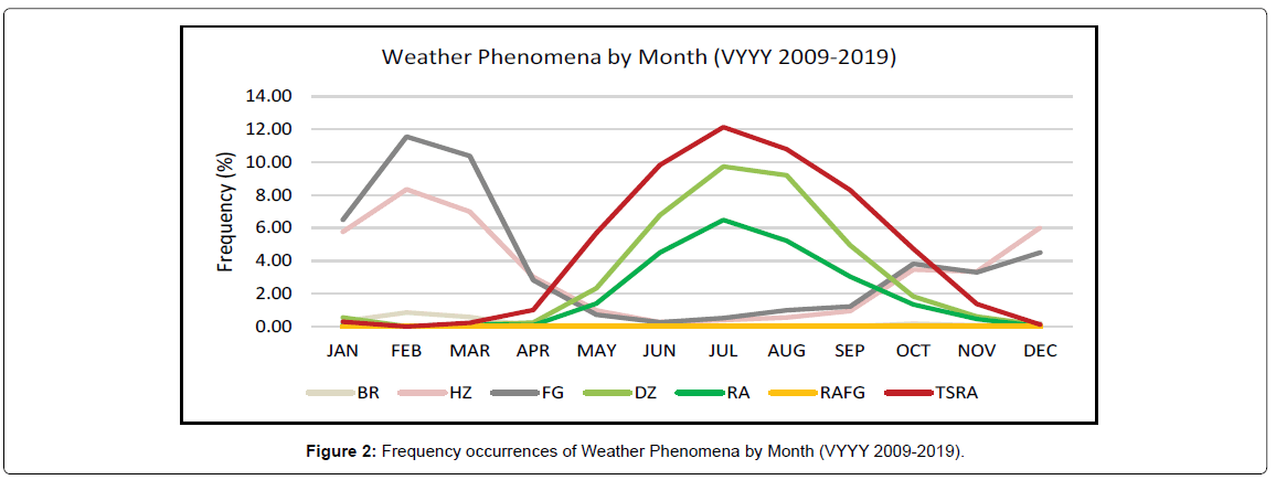
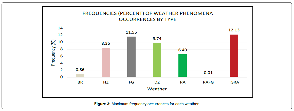
Maximum frequency occurrences for each weather phenomenon are colored in a Table 1. Mist (0.86%), Haze (8.35%), and Fog (11.55%) are maximum frequency in February. For maximum Drizzle (9.74%), Rain (6.49%), and Thunderstorm (12.13%) occurred in JULY during 2009-2019 (Table 1 and Figure 2). There are three seasons in Myanmar-
| MEAN FREQUENCIES (PERCENT) OF WEATHER PHENOMENA OCCURRENCES BY MONTH |
|||||||
| MONTH | WEATHER PHENOMENA | ||||||
| BR | HZ | FG | DZ | RA | RAFG | TSRA | |
| JAN | 0.32 | 5.77 | 6.50 | 0.56 | 0.11 | 0.01 | 0.29 |
| FEB | 0.86 | 8.35 | 11.55 | 0.03 | 0.00 | 0.00 | 0.00 |
| MAR | 0.59 | 7.00 | 10.38 | 0.11 | 0.17 | 0.00 | 0.23 |
| APR | 0.02 | 3.03 | 2.83 | 0.25 | 0.09 | 0.00 | 1.01 |
| MAY | 0.02 | 0.99 | 0.73 | 2.34 | 1.41 | 0.00 | 5.70 |
| JUN | 0.01 | 0.27 | 0.27 | 6.78 | 4.51 | 0.00 | 9.83 |
| JUL | 0.00 | 0.41 | 0.52 | 9.74 | 6.49 | 0.00 | 12.13 |
| AUG | 0.04 | 0.56 | 1.00 | 9.20 | 5.22 | 0.00 | 10.79 |
| SEP | 0.03 | 0.96 | 1.23 | 4.95 | 3.05 | 0.00 | 8.31 |
| OCT | 0.18 | 3.47 | 3.82 | 1.83 | 1.35 | 0.00 | 4.74 |
| NOV | 0.09 | 3.34 | 3.30 | 0.62 | 0.47 | 0.00 | 1.38 |
| DEC | 0.21 | 6.01 | 4.51 | 0.10 | 0.03 | 0.00 | 0.13 |
Table 1: Monthly Frequency Percentage table of weather phenomena that occurred.
1. Winter or Northeast monsoon season (November - February),
2. Summer or Hot weather season (March - Mid May) and 3. Rainy or Southwest monsoon season (Mid May - October) as by Myanmar Climate Report 2017 [11].
Fog and Haze weather phenomena are maximum occurred during winter. But Thunderstorms have occurred maximum during half of summer and the whole rainy seasons. As the result of Figure 2, not less than 8 months had occurred maximum thunderstorm condition in Yangon International airport.
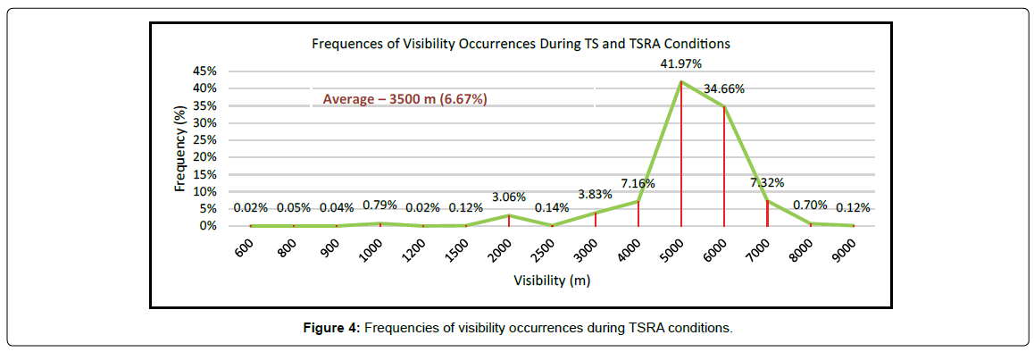
Snow, fog, thunderstorms, turbulence, and dust storms are all significant weather influences on the aviation business. As shown in Figure 3, the main weather phenomena at Yangon International Airport are Thunderstorms (TS) and Fog (FG). Thunderstorms wreaked havoc on airport operations because of the numerous types of weather that followed, including hail, strong winds, heavy rain, lightning, and extreme turbulence. All of these factors have a significant impact on aircraft and airfield operations. During thunderstorm (TS) and thunderstorm rain (TSRA) conditions, visibility at Yangon International Airport ranged from 600 to 9000 meters. With a frequency of 41.97 percent, the value of the maximum occurrence is around 5000 meters. And the smallest value is 600 meters, which is only 0.02 percent. From 2009 to 2019, if all readings are averaged, visibility will be 3500 m with a 6.67 percent average (Figure 4).
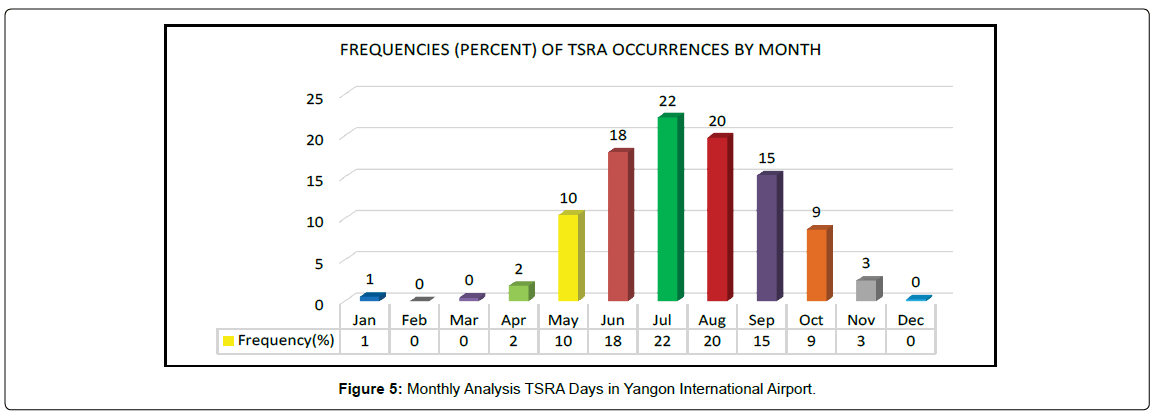
The following is a monthly analysis of thunderstorm occurrences from 2009 to 2019. The frequency occurrences percentages are shown in Figure 5 The largest frequency is 22% in July, the lowest is 1% in January, and the months with no occurrences are February, March, and December with 0%. The Southwest Monsoon season begins in July, according to the seasonal distribution. Thunderstorms are common during the rainy season. Tropical cyclones from the Bay of Bengal or the Western Pacific, on the other hand, are the main cause of thunderstorms in the winter and summer.
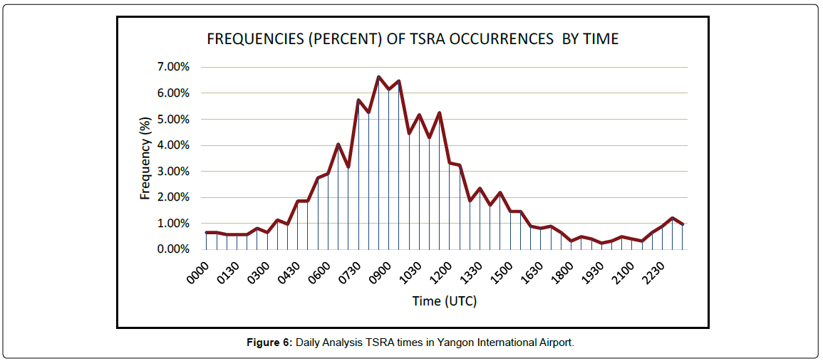
Figure 6 shows the daily frequency occurrences percentage for TSRA from 2009 to 2019. TSRA weather is most likely to occur between 08:30 and 10:00 UTC during the day. The minimum frequency may occur between 19:00 and 2000 UTC. According to time zones, local time will be 15:00 at 08:30 UTC. Maximum TSRA occurrences at Yangon International Airport may occur between 15:00 and 16:30 in the afternoons on particular TSRA days. On such TSRA days, the ideal time for daylight aviation operations is 00:00 UTC to 04:00 UTC.
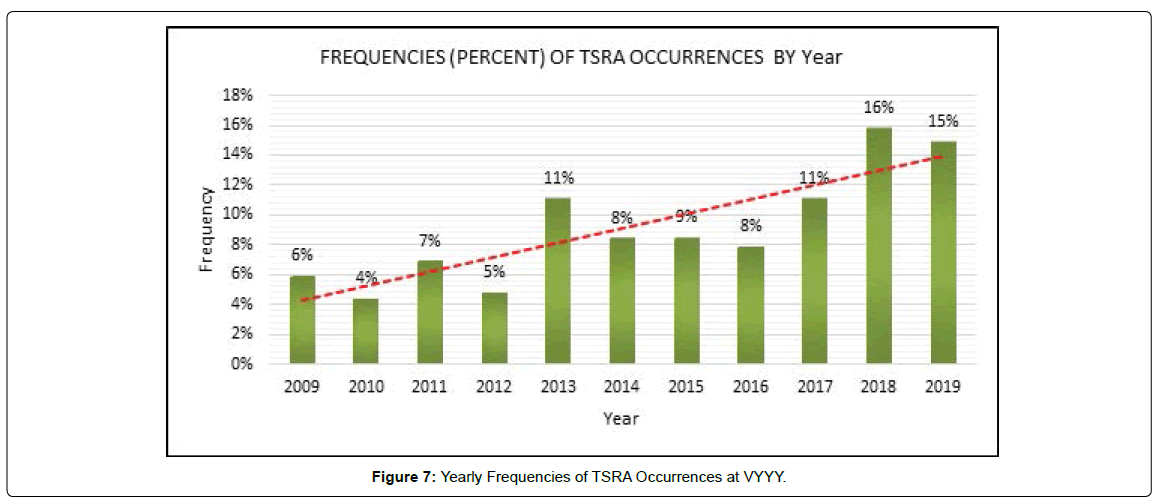
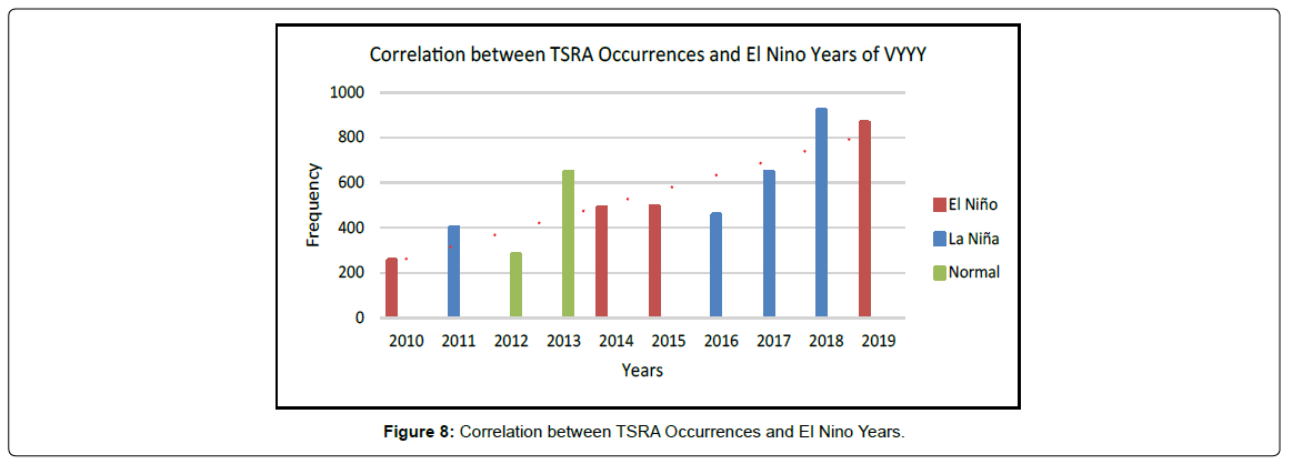
A yearly frequency study demonstrated how TSRA days occurred more than once per year (Figure 7). The least number of occurrences in these eleven years is 255 in 2010. The average number of occurrences is 527, with the highest number of occurrences in 2018 being 920. Some of the instances correlated with El Nio/La Nia events. Because Yangon International Airport is located in the Western Pacific tropical region, where El Nio/La Nia occurrences have a direct impact. Even though these El Nio/La Nia events aren't factored into the equation, the trend of TSRA occurrences is increasing year after year (Figure 8). According to the trend forecast, TSRA days will normally increase at VYYY in the future.
Moisture, Instability, and Lifting are three components in meteorology that must be present for a thunderstorm to form, according to various studies. The combined amount of work that the upward (positive) buoyancy force would perform on a specific mass of air (called an air parcel) if it climbed vertically through the entire atmosphere is known as convective available potential energy (CAPE). In meteorology, the K-Index is also a measure of thunderstorm potential. The index is based on measures such as "vertical temperature lapse rate, lower atmosphere moisture content, and the vertical expanse of the moist layer," according to the NOAA.
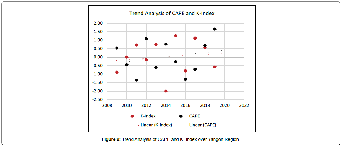
As an above objective performed the trend analysis for annual CAPE and K-Index over the airport regions. The results show up or increasing trend of CAPE and K-Index, and increasing year by year as the trend forecast (Figure 9). Thus, need to find the reason for the increasing trend.
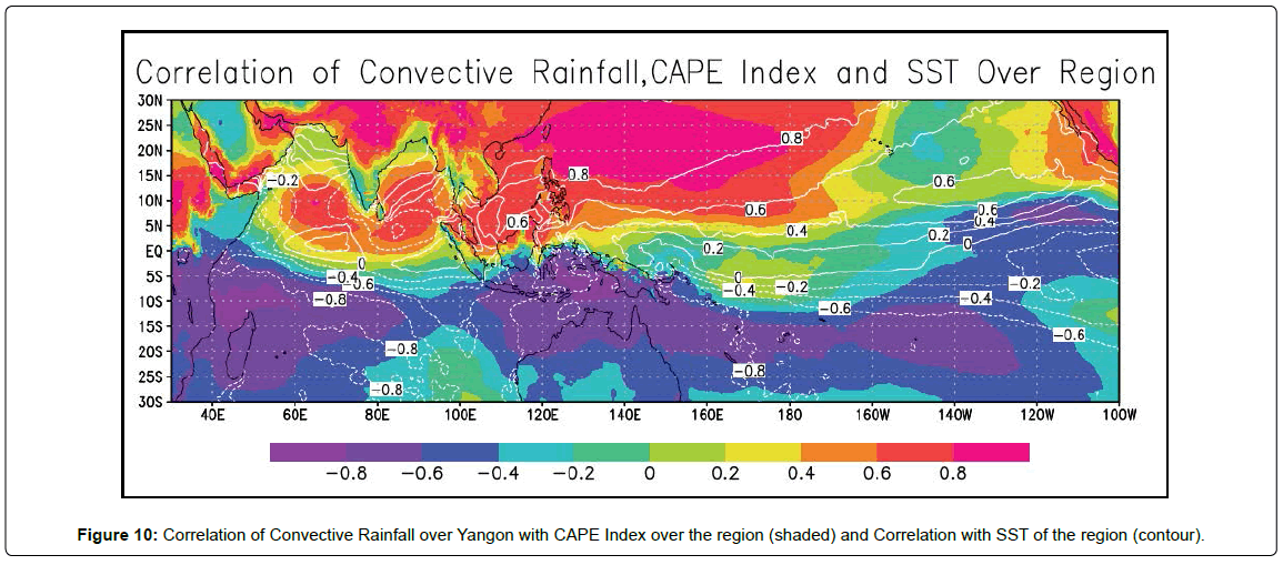
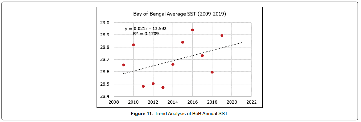
Thus, as a deep analysis, we performed a correlation between convective rainfall over Yangon with CAPE Index and SST over the region of India ocean and North West Pacific where is the high teleconnection area to the India Monsoon system. Then, we found that the Bay of Bengal CAPE Index had a high positive correlation value with convective rainfall over the airport region by the analysis results (Figure 10). And Nino area is only below 0.2 value and the BoB area is 0.6 to 0.8 for convective rainfall value with SST (Figure 11). It means that TSRA or convective activities occurrences over airport region are positive correlation with the BoB SST.
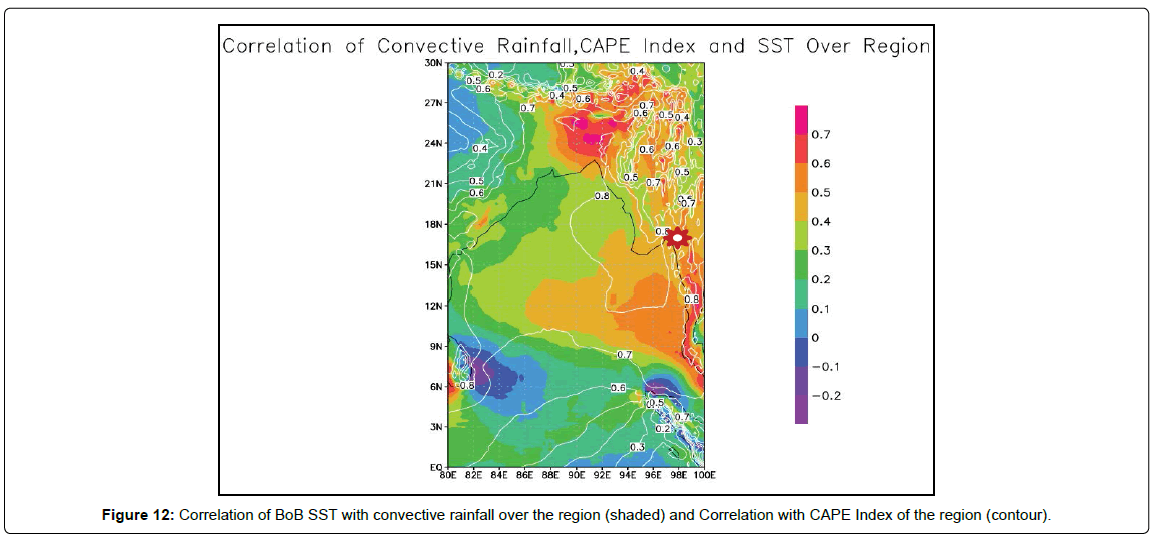
Then there's a thorough examination of the surface temperature of the Bay of Bengal Sea. As a result of a trend analysis with strong regression, we discovered that it is likewise increasing year after year. After examining the relationship between BoB SST, convective rainfall over the airport region, and the CAPE Index, we discovered that both the CAPE index and convective rainfall over the airport region are strongly connected with BoB SST, with values ranging from 0.5 to 0.8. (Figure 12). It mean BoB SST is the key localize factor of increasing trend of TSRA occurrence over the study area.
Conclusion
To summarize, airports are significant national resources for all countries across the world, and the safety of each aerodrome plays a critical role in the aviation sector. Weather is the uncontrollable factor in aerodrome safety, having a significant impact on aircraft and airfield operations. Thunderstorms are the worst weather phenomena at VYYY, according to the survey results of a crucial online question, and fog is also the worst. The worst weather phenomena at VYYY are raining during airplane approach due to poor visibility and a strong gust wind. However, the majority of them are caused by thunderstorms. As a result, we may assume that poor visibility, a low ceiling, and thunderstorms and fog are the worst weather conditions for Yangon International Airport. Visibility, cloud ceiling, and thunderstorm or fog conditions are also critical for airport and airplane operations. Maximum thunderstorm occurred in July and minimum frequency in January. No occurrences months are February, March, and December. In daily analysis, the maximum frequency of TSRA weather may occur 08:30 to 10:00 UTC during a day. The minimum frequency may occur from 19:00 to 2000 UTC. Even in the year of El Niño or La Niña events, the trend of TSRA occurrences is up or increase year by year. So, we can assume that any El Niño or La Niña events do not concern with that increasing trend. CAPE and K-Index, over the airport region, also increasing year by year. TSRA or convective activities occurrences over airport region are positive correlation with the BoB SST and negative correlation with the Nino region SST over Pacific. Bay of Bengal sea surface temperature also increasing year by year as trend analysis with strong regression. After tested the correlation between BoB SST, convective rainfall over airport region, and CAPE Index, we found both CAPE index and convective rainfall over airport region are highly correlated with BoB SST. Thus, BoB SST is the one dominant factors for TSRA occurrence increasing at Yangon International Airport region and further factors may need to study. As noted by a well-known physicist in another context, the current finding poses a new question, as well as a fresh opportunity to look at climatology from a different perspective, and to make significant progress in the predictability study.
Acknowledgment
I'd also like to thank the Department of Meteorology and Hydrology for supporting Myanmar data, as well as Professor Larry Oolman of the University of Wyoming's Department of Atmospheric Science for supporting METAR data for airfields. Special gratitude to Professor Badri Jijelava, Head of met office; at SAKAERONAVIGATSIA for supporting research ideas and analysis techniques. Finally, special thanks to Professor. Haishan Chen, Professor Wang Wen from Nanjing University of Information Science and Technology, for supervisor this paper and his others, support during this research.
References
- Gittens A, Hocquard S, Juniac A de Liu F, Fanning E (2019) Aviation Benefits Report. Convention on International Civil Aviation p: 76.
- Goodman CJ, Griswold JDS (2019) Meteorological impacts on commercial aviation delays and cancellations in the continental United States. J Appl Meteorol Climatol 58: 479–494.
- Kulsea G (2002) Weather and Aviation: How does Weather Affect the Safety and Operations of Airports and Aviation and How Does FAA Work to Manage Weather-related Effects? The Potential Impacts of Climate Change on Transportation Workshop Pp: 1–10.
- Puempel H, Williams PD (2016) The impacts of climate change on aviation: scientific challenges and adaptation pathways. ICAO Environmental Report 2016: On Board A Sustainable Future Pp: 205–207.
- Atkinson G, Ramage C (1991) Forecaster’s Guide to Tropical Meteorology. Weather Graphics (April 1971).
- Thunderstorm | Definition, Types, Structure, & Facts | Britannica. (n.d.). Retrieved December 21, 2021.
- Federal Aviation Administration (2012) Fueling Inspections. International and FAA Fuel Fueling Safety. ICAO Annex 14, Chapter 9. June.
- Anaman K A, Quaye R, Owusu-Brown B (2017) Benefits of Aviation Weather Services: A Review of International Literature. Res World Econ 8 p: 45.
- Jijelava B (2019) Climatological Summary of the Georgian Aerodromes 2010-2018.
- Emery WJ (2015) Air Sea Interactions: Sea Surface Temperature. Encyclopedia Atmos Sci: Second Edition, 136–143.
- Aung LL, Zin EE, Theingi P, Elvera N, Aung PP, et al. (2017) Myanmar Climate Report. Nor Meteor Inst 9 p:105.
Citation: Oo KT (2021) A Decade Trend of Thunderstorm Days at Yangon International Airports (Analysis base on Half-Hourly Observation Data From 2009 to 2019). J Earth Sci Clim Change 12: 594.
Copyright: © 2021 Oo KT. This is an open-access article distributed under the terms of the Creative Commons Attribution License, which permits unrestricted use, distribution, and reproduction in any medium, provided the original author and source are credited.
Share This Article
Open Access Journals
Article Usage
- Total views: 2061
- [From(publication date): 0-2021 - Dec 06, 2023]
- Breakdown by view type
- HTML page views: 1672
- PDF downloads: 389

